RSS

Author Archives: Matt Hunt

Chase Log: May 26, 2016 – Ashland/Coldwater, KS

This day had been on my radar (no pun intended) for a while as THE day of this week. It was the day that featured the strongest winds at 500mb. During the early part of the week, it was looking like a classic dryline tornado outbreak in western Oklahoma. Things really began changing as the day got closer, however. By the afternoon of the 25th, it was looking like NW Kansas into Colorado was going to be the best spot, to the north of the surface low.

The morning of, everyone was hyping this day up, including the SPC, who issued a moderate risk over central Kansas along the warm front. I got up early, thinking I’d be making a 9-10 hour drive to NW Kansas. However, I spent literally hours in the morning debating between that spot, central Kansas, SW Kansas/NW Oklahoma, SW Oklahoma, AND west Texas! I could make a case for every target! That being said, my hopes were not nearly as high as everyone else. The HRRR was breaking out a boatload of JUNK early in the day over western Oklahoma into central Kansas. It was also dropping dewpoints significantly all throughout western Kansas, as a result of downward transport of dry air from ongoing overnight convection (per SPC).

I figured those storms along the warm front would be really messy, as warm front storms typically are anyway. Nonetheless, I thought this was probably going to be the best spot to see a tornado, so I left Carrollton around 9am with a target of Salina, KS. I was already way behind.

As I approached OKC and that junk I spoke of previously was going up and beginning to intensify, I realized I wasn’t going to catch it. I actually liked the prospect of more isolated storms in NW Oklahoma/SW Kansas along the dryline, so I began heading that way. A couple storms broke out as I was on my way, and I approached my first storm of the day, which was severe warned, near Arnett, OK.

Long story short, it was very high-based, had some decent hail in it, but that’s about it. I followed a little ways, then let it go. Back to the west in the Texas panhandle, it appeared further initiation off the dryline was starting. I went southwest to Shattuck, OK and stopped there, as these storms seemed to be struggling to develop. Finally, the cell to the north began intensifying, and I raced north to catch it. I got to it near Englewood, KS.

DSC_0346

Another high-based storm. I wasn’t very hopeful for tornado chances when I saw that. I followed it north and then east, and went through some pretty good hail, maybe up to ping pong ball size (1.5″) at most. I finally noticed the distinct sound of the hail hitting my sunroof hail guard during this barrage, and I was glad I had that!

Out in front of the storm, it did have some great structure!

DSC_0348

DSC_0366-Pano

I stayed in front of it for a while, then it finally died near Greensburg as I felt the ice cold outflow coming from the storm. Time to call it a night. Well, maybe.

As I got south of the storm, I noticed a beautiful scene and had to stop! I could see mammatus forming at the top of this storm, with the updraft of another to the south, as the sun was beginning to set over a wheat field. What a beautiful scene!

DSC_0424

I just love those wheat fields. Especially the way they wave in the breeze. This to me is the very essence of the Great Plains! It is far from boring, especially with those violent storms!

Unfortunately I wasn’t going to get a great mammatus shot, as low clouds expanded and took over this scene. It was still amazing to see the orange glow on the wheat fields as the sun set!

DSC_0431

After going through Coldwater, I headed back west and noticed quite a lightning show going on! I got a KILLER shot of an anvil crawler, but came to find out later it was not in focus! Ugh! I had been zoomed in on an updraft earlier and forgot to re-focus (it was on manual focus) after going back to wide angle. That’s not the first time I’ve completely forgotten I was on manual focus and it needed to be changed!

I was at least able to get several great shots of lightning darting through the sky around a new updraft!

No tornadoes for me on this chase, though I apparently missed one RIGHT where I had been earlier in the day; Arnett, OK. So again, I nailed the forecast, but just wasn’t there!

 
Leave a comment

Posted by on May 31, 2016 in Chase Logs


Tags: , , , , , , , ,

Chase Log: 5/24/16 – Minneola/Dodge City, KS

There was a pretty obvious target on this day where the surface low, outflow boundary, and dryline all met. Dodge City, KS was my target, but I planned on going wherever that outflow boundary ended up. My hopes weren’t SUPER high for this day, but I liked the prospect of seeing a tornado, and by the morning, the SPC had increased the tornado risk to 10% for this small area in SW Kansas into NW Oklahoma.

I didn’t want to take a chance on being late, so I left Carrollton at 6am in order to avoid rush hour traffic and give myself plenty of time. This ended up being WAY too early, as I arrived in Woodward, OK by noon. I would proceed to spend the next 4 hours or so hanging out in the Wal-Mart parking lot with a group of chasers! It was not time wasted, however, as I met some cool people! At the 3pm outlook, the SPC upgraded to a 10% hatched tornado risk in that area!

With towering Cu starting to build, and the outflow boundary retreating back to the north, we decided to reposition further north, and headed up to Buffalo, OK. This still appeared to be too far south, so we continued on into southern Kansas. Here we had a tower going up to our west. It was about 5pm at this time. I noted that it was moving due north, and that we needed to continue to Minneola, KS.

The storm started as a cluster of 4 small cells, but ended up merging and developing pretty rapidly, getting a nice supercellular shape on radar. Here is the very first picture I took when we stopped just south of Minneola.

DSC_0279

A couple of things to note on this picture: The flat, smooth base, inflow tail, and striations in the updraft. This had all the makings of a fantastic storm, even though it was early in its development. It already had a tornado warning on it at this time, as radar was beginning to show some rotation. Visually we could tell it wasn’t about to drop a tornado, but it was getting to that point quickly. It wasn’t long before a wall cloud started to form, and we decided to go ahead and get north of town prior to tornadogenesis.

The wall cloud had persistent rotation and a funnel cloud for several minutes.

DSC_1633

Finally that funnel reached down and made contact with the ground, and we had our first tornado just one hour after initiation!

DSC_1636

This tornado remained thin for a while, danced around a bit, and appeared to be ready to rope out before coming back stronger, and building into a big stovepipe! I moved north to stay up with it, but it appeared to be moving off to the west as well.

DSC_1642

I continued north, noting another rapidly rotating wall cloud to the east of the tornado. It was evident that another tornado was on the way, and it would touch down prior to the first tornado roping out! I got up to Ford Ensign Rd and began tracking east to get closer. At this time, yet another wall cloud was to the east, and TWO skinny rope tornadoes came down!

DSC_0307

I didn’t think I captured this, but I actually did in the above photo. There’s a very skinny rope to the left of the more prominent rope, and if you look at the dust on the ground, you can tell that it has a separate dust whirl.

The main tornado turned into a beautiful light grey stovepipe, kicking up dark brown dirt as I moved closer to it heading east. I had to stop, however, when I reached a beautiful wheat field, which was the perfect foreground and created this incredible scene!

DSC_0316-4

This was a shot I had been dreaming of! I felt like I was fairly close to this tornado at one point, maybe a couple miles, but it was moving away from me. The above picture was shot at 11mm, so the top of the picture was basically what was directly above me. It’s a large field of view. Here’s a shot from my D5100 taken at 32mm, which is just about a perfect representation of what the eyes see.

DSC_1650

This was hands down the most photogenic tornado I had ever seen, and to have a second one on the ground at the same time was icing on the cake!

DSC_1654

This tornado would rope out shortly after the above photo, then actually touched back down as a skinny rope. I would find a paved road going north and made one more stop when these tornadoes had dissipated, when I saw another brief spin-up underneath a bowl funnel. It was apparent, however, that a big tornado was about to happen. There was a large area of rotation getting closer and closer to the ground! We were about to have a wedge!

I went north all the way to Hwy 56 while watching the wedge form, then I stopped there to shoot video of it moving away, and snap more photos. Another chaser pulled up and said in 46 years of chasing he had never seen anything like this!

DSC_0336

After leaving this spot I got bogged down in Dodge City a bit, and fell pretty far behind the storm. I witnessed another tornado touch down while I was in the town, but couldn’t get a good picture of it.

DSC_0338

The above picture is the end of the wedge, I believe. East of town I witnessed another two tornadoes touch down before going north on 283.

DSC_0339

At this point the storm was about to get cut off by a new storm to the south, and rain started interfering with it. I thought it was done, and sat and waited for a while, but then rotation began picking up on the wall cloud again, so I continued north. One more tornado touched down! All I have is a cell phone picture of that one.

It’s tough to get an accurate count on the number of tornadoes on this day, especially near the time when there were 3 tornadoes at once, as it seemed like there may have been several different ropes dancing around that huge wall cloud. Other chasers have said 12, and I’ve heard even as many as 17! I think my number is still conservative, but is likely the best representation of what I actually saw with my own two eyes.

After that, I was starving, and it was time to celebrate, so I linked back up with my buddies for a steak and a beer!

This chase was a great example of the kind of influence an outflow boundary can have on a storm. The environment was conducive to tornadoes, but I don’t think we would have seen this prolific of a storm without the interaction of that outflow boundary. It’s amazing how you can see tons of storms that just struggle and struggle to produce, and aren’t able to, and then this storm it was basically a given with each new wall cloud that another tornado was imminent! Whenever there is an outflow boundary, that should be your target! Period!

This was by far my best chase day ever. My previous high was 4 in one day, so that was blown away! I came into this year having seen 9 tornadoes TOTAL in nearly 7 years of chasing, and eclipsed that all in the span of about 2.5 hours! In hindsight, I wish I would have made the effort to get closer to these tornadoes, as they were moving very slow, and it was the perfect terrain and storm to come up behind them safely. That being said, I really love the shots I got of the tornado plus the incredible structure of the storm. It’s funny, last year in Elmer I was a bit jealous of those who had been further back, as that storm had some amazing structure, and on this day I was a bit jealous of those who were close! I can make a case for preferring either location, really. I may just have to alternate with each chase!

I may not ever top this chase, but you never really know what Mother Nature has in store!

 
Leave a comment

Posted by on May 28, 2016 in Chase Logs


Tags: , , , , , , , , , , , ,

Chase Log: May 23, 2014 – Hedley, TX

I went to bed the previous night planning on targeting the dryline bulge in Woodward, OK. When I awoke, it appeared on some of the models that this dryline bulge was not going to happen. It also changed the surface winds somewhat in that area, and they were no longer as backed as they had been previously.

The spot that I was in actually didn’t look too bad, so I hung around Sweetwater. I questioned if storms would fire later on in the day, however, and ended up moving north into the panhandle. As I approached Childress, a storm had fired… game on!

I timed it pretty well, and the storm looked pretty good as I approached.

DSC_0235

I got to a rest stop just east of Hedley that had a good view. It was high-based still, and low-precipitation, which was beautiful, but not anything that was about to produce a tornado.

DSC_0253

I continued north and found a huge line of chasers on the side of the road north of Hedley. I went all the way to the end of the line to park. Coincidentally, I ran into a couple old friends who were right across the street, Blaize Edwards and Adam Davis! I chased with those two on April 14, 2012, and they also bailed me out last year in Elmer, OK after I wrecked my car. We had been in touch that day, but I didn’t know exactly where they’d be.

DSC_0265

We sat there and watched as this storm took a crap. From there we decided to drop south to Turkey, but as we were on our way, those storms died, too. The anvil tops of these storms were drifting southeast for some reason, and we figured they were choking on their own outflow. We called the chase at 6pm in Childress, and I took off east to head home for the night.

Of course as I was driving home, storms began to intensify, and there was a tornado near Turkey, but it was after dark, so I wasn’t too bummed about missing it. I was more upset that I hadn’t stuck with my original target of Woodward, OK, however, as there was a beautiful cone tornado at sunset just north of town!

This ended a streak of 4 consecutive chases with a tornado!

 
Leave a comment

Posted by on May 28, 2016 in Chase Logs


Tags: , ,

Chase Log: May 22, 2016 – Big Spring, TX Tornadoes

I went against the grain on this chase and picked a target that was far removed from where almost every other chaser was in the TX panhandle. I saw models breaking out storms early, and away from the dryline up there, and didn’t think the tornado potential would be as great. I liked the dryline bulge further south in west Texas, and chose Big Spring as my target.

When I got to Sweetwater, it appeared Big Spring might end up being too far west with the advancement of the dryline, so I stayed put for a little while. When it looked like we had initiation near Post, I started heading that way. That little cell died, however, so I didn’t go any further north than Snyder. I had actually started west toward Gail when I lost data, so I went back east to Snyder, then saw cells firing to the west, and went back west!

I caught up with my first storm of the day near Ackerly, TX. The issue I saw with this cell was interference from the cell to the south. However, it did have a wall cloud on it, so I stuck with it for a little while with the plan to drop south once it was completely cut off. It did have some decent structure to it.

DSC_0081

I knew that I needed to be on tail-end Charlie, however, so I let that storm go and started my way south toward my original target of Big Spring.

Just north of town on 87 I was able to see the base, and things were looking pretty good! I had expected more easterly movement, but it seemed this storm was moving straight south, so I went around Big Spring and headed west on 176. This storm really began intensifying at this point, was tornado-warned, and had a hook developing on radar. I snapped this photo looking west as the inflow really began to pick up.

DSC_0098

I saw some dust on the ground to the southwest and thought that was a tornado, but then noticed it was all moving in one direction… gustnado. A few minutes later there was another spin-up, this time rotating… tornado! I reported it on Spotter Network, then continued to 2599 to drop south.

At this point that first spin-up had dissipated, but inflow was getting VERY strong! I knew I was very close to a developing tornado, but the storm was messy and I couldn’t tell exactly where it would happen. Then I did see another spin-up, and this time I could see the clouds above it rotating. It looked like this could evolve into a big wedge! Multiple vortices were spinning around the parent rotation. I’m not good at judging distance, but I was not very far away from it, maybe a mile or so. I did not feel unsafe, however, with the storm moving south, and me being north of it.

This became completely wrapped in rain, and I couldn’t discern any ground rotation. I continued south and when I got to I-20 I was pretty sure I could see the left edge of a big tornado! I was paying close attention to the collar cloud, which was directly above me. I did not want to advance too quickly, and in fact at one point I got hit with strong winds and blinding sheets of rain out of the east. I turned around and went back north until I was out of that. I could have potentially been in the outer circulation of the tornado at that point! Looking at the radar, I was basically right on top of the couplet!

When I turned back around all I could see was a big wall of rain. Ben Holcomb, a very seasoned chaser, was right in front of me, and I pulled up and asked him if he could see it, and he said he was pretty sure that whole thing was a big tornado. We started moving across the interstate when I noticed HUGE hail stones falling! They were at least baseballs, some looked bigger! When I got to the access road, there were even more big stones falling. There were some vehicles parked under the overpass, but it looked like there was room for me, so I ducked under there to avoid losing any windows. Unfortunately this made me lose touch with the storm, and it would continue to drop more tornadoes further south… or perhaps that was still the same tornado, I’m not sure.

Eventually I punched through the core, and luckily only encountered half-dollar sized hail. It likely put some new dents in the car, but I didn’t lose any windows. Out in front of this storm I saw some beastly structure, but was not able to get to a good spot for a photo. The lightning was incredible, frequent, and surrounding me, so I wasn’t comfortable getting out of the car!

I was able to get in front of the storm east of Garden City and get a few shots as the sun was setting.

DSC_0126

It ended up producing another tornado near Garden City, but I let it go at that point, not wanting to chase an HP storm at night!

Click here for a link to the storm survey.

Below are my two videos, one from my Handycam before it locked up, and the other from my D5100.

 
Leave a comment

Posted by on May 28, 2016 in Chase Logs


Tags: , , , , , , , , ,

Active Severe Weather Week: May 22-28

Next week is the second week of my two-week chasecation, and I don’t know that I could have planned it any better! It’s looking like a VERY active week, and could potentially have chasing opportunities every single day of the week. This is a result of a persistent trough bringing decent mid-level west/southwest flow all week, and a sharp dryline with a very moist, very unstable warm sector in place through the southern plains.

500mb winds aren’t forecast to be incredibly strong, which reduces the tornado threat somewhat, however the atmosphere will be very unstable, and directional shear will be nearly ideal almost every day of the week, with backed surface winds veering to WSW winds at 500mb. The advantage to the somewhat weak flow is that storms are going to be moving slow, which makes chasing so much easier!

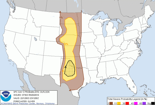
Here are the SPC outlooks for the week:

Sunday
day3prob_0730

Monday
day4prob

Tuesday
day5prob

Thursday
day7prob

There will be chances on Wednesday, Friday, and Saturday as well, but there’s not enough information to outline a risk area yet. As you can see, I may never have to go very far from home, either! Every single day includes western Oklahoma into north-central Texas. Of course I will go to the spot I feel has the greatest chance for tornadoes.

 
Leave a comment

Posted by on May 20, 2016 in Forecasts


Chase Log: May 16, 2016 – Felt, OK & Perico, TX Tornadoes

Sometimes a bit of luck turns a chase with low expectations into a great chase. This was one of those days! Several days prior, this looked like it could be a big day, but there was a huge lack of consistency in models from run to run, and by the time it was the day of, it looked as though tornado chances would be fairly limited.

I set out with a target of Stratford, TX. This wasn’t a very difficult decision, as I was basically targeting the triple point. By evening, the surface low was going to be in NE New Mexico, with a warm front extending east through the Oklahoma panhandle, and a dryline going south/southeast through the Texas panhandle. Earlier in the day, these features had a bit of a different placement, but I didn’t expect storms to be doing much early on. I expected initiation further west in New Mexico, or possibly SE Colorado, but I figured it would be at full strength at or near Stratford.

Storms did fire early, and seemed almost stationary in the NE corner of New Mexico. Additional storms traveled NE into Colorado, but I was not worried about those, as they were going to cross the boundary into less favorable air. I was still SE of Amarillo at storm initiation, but was able to get to the dominant storm before it had really done anything.

I headed east out of Boise City, OK on 325 until it curved north, and stopped there to watch the storm. It was a little unorganized at that point, but looked promising. I did not have any radar data at that time, so I could not tell what it looked like in that respect. It seemed to be moving more south than east, so I dropped south toward Felt.

Here the storm started looking better. There were a lot of low clouds, but looking through them I could see a big striated updraft tower. This storm was starting to get its act together!

DSC_1498

The structure was pretty textbook at this point, and we had a wall cloud forming, and inflow picking up. I kept watching the wall cloud to the right of the rain shaft, but then I noticed a funnel right in the center of the rain. It appeared to touch down, then it became obscured with rain again. I re-positioned further south where the rain started to let up, and the funnel became more visible.

DSC_1506

I was unsure at the time whether it was touching down or not, but video from Reed Timmer almost directly underneath it does show some ground circulation at that time. As you can see in the photo above, there was also a very nice wall cloud to the east of the tornado, and I was hoping this would eventually produce, and stay clear of the rain.

Dropping further south to stay with the storm, the wall cloud picked up some rapid rotation as inflow really started streaming into the storm.

DSC_1510

The first tornado was actually still ongoing in the above picture, and you can vaguely see it on the left edge of the wall cloud, back there behind the rain. As rotation on this new wall cloud picked up, it seemed as though the RFD advanced east and began wrapping around this wall cloud. I was afraid rain may again obscure the tornado if this storm did drop another.

From the town of Felt, I traveled east a ways to get out in front of the rain. When I parked and looked behind me, I saw a big cone tornado! I didn’t get any still photos of it, but I do have some good video (see below).

Staying out in front of the storm, it looked a little more unorganized, but still very strong. There was still a lot of inflow feeding into the storm, so I wasn’t worried about it gusting out anytime soon.

DSC_1515

I continued south on 385 as this storm exhibited strong rotation on radar, but I could not see any well-defined lowering. I went right through the RFD, which was pretty strong, looking for a good east option. Unfortunately this is right in the middle of the Kiowa and Rita Blanca National Grasslands, and none of the roads I passed were paved. I’d have to go all the way to Dalhart, then northeast on 54 to get back in front of this storm.

I hadn’t been paying any attention to other storms, but just so happened to look to the west and noticed a funnel cloud off in the distance. I couldn’t tell if it was on the ground or not (confirmed later from other chasers that it was).

DSC_1538

After that I attempted to get back in front of the first storm, now approaching Stratford, but I was unable to beat it to town. Looking at pictures from other chasers, that thing turned into quite a beast with some beautiful structure, so it sucks that I missed that, but unfortunately you can’t be on all of the storms at once!

At this point I felt as though tornado chances were diminishing, plus I was hungry, so I continued south to Amarillo for a steak! This has long been a tradition of chasers to get a steak after seeing a tornado, but I had actually never done it! I did have to make one last stop for a photo, however, after getting well out in front of the storms and seeing the beautiful structure as the sun was on its way down for the day.

DSC_1547

Three tornadoes is my 2nd best chase day ever in terms of numbers, and gives me 6 now for 2016, which is the best of any year yet. However, none of those 6 have been the truly photogenic tornado I seek! It looks like there might be a few days with more opportunities next week, so we’ll see what happens! Chase season is still far from over!

Here is my video from the chase:

 
Leave a comment

Posted by on May 18, 2016 in Chase Logs


Tags: , , , , , , , , , , ,

Chase Log: May 9, 2016 – Boswell & Hugo, OK Tornadoes

This was a chase unlike any other in that I had not even planned on chasing, and therefore really didn’t look at any models or have any plan in place prior to leaving! I expected things to be too far off to the east, and didn’t think I’d have a chance to see anything after work. About the time I was finishing up at work, I saw a text from my buddy Rob about a tornado in Oklahoma. I pulled up RadarScope on my phone and saw that this cell was right over I-35 at the time. Hmm, I thought maybe if I left immediately and shot up 75 I could catch it.

I rushed home, grabbed my equipment, and headed out. The X-factor would be rush hour traffic. This is the DFW Metroplex! The good thing was that the storms were to the north, which is the quickest way out of town for me. It became apparent that I could not catch up to that dominant cell, which was also about to get some interference with the cell to the south of it, anyway. However, there was a cell that had just fired near Sherman that I figured I could catch. Luckily these storms weren’t moving very fast, maybe 30 mph or so.

From Durant, OK, the main road heading east was 70. At the time, the storm was almost centered over 70, and seemed to be taking an ESE track. So I decided to take 70E instead, as it ran further to the south, though it routed back to the north in Bennington, OK. Well, this turned out to be a mistake, and only cost me precious time, as I didn’t gain any ground on the storm, and was still behind it by the time I got back to 70.

Once on 70 I was finally able to catch up to it, and it also changed its track and started heading more ENE, bringing the area of interest within view. Just before getting to Boswell I saw a funnel that was not fully condensed to the ground, so I couldn’t confirm that it was a tornado at the time, but damage surveys did confirm this was still on the ground.

Boswell OK Tornado 2

The view was limited with all of the trees, and since I was still behind it a ways, I just kept driving instead of stopping at any clearings. That tornado dissipated, but there was a large wall cloud right in front of me, and I knew it could produce again. Looking at the radar, I was still quite a ways behind this rotation, so I continued east at max speed, passing others who were creeping along!

I was pretty much right on this storm’s tail when I got to Hugo, OK, and noticed a funnel cloud. Again, I could not confirm ground contact at that moment, but when I continued into the town of Hugo, the damage told me that it was on the ground. The damage wasn’t horrible, but a lot of tree limbs were down, power lines down, glass broken, sheet metal strewn about, and shingles torn off of roofs.

Hugo OK Tornado

I attempted to follow this storm by taking the first north option out of Hugo, but it became apparent that this was taking me too far north, so I turned around. At this point I felt like this storm was losing some of its punch, and I had time to get south and get in front of the storm approaching Paris, TX. So I left Hugo and dropped south.

Luckily the storm was moving slow enough that I was able to get through the eastern end of the storm and avoid the bigger hail. This storm actually had some good structure on it, and just north of Pattonville, TX I was able to find a nice clearing to view the storm at sunset. The inflow was picking up, and I thought this storm just might produce!

DSC_0658

It never did produce, but it sure was beautiful, and a great way to cap off the chase!

 
Leave a comment

Posted by on May 18, 2016 in Chase Logs


Chase Log: May 8, 2016 – Marlow, OK Tornado

This was a setup that looked really great a few days out, and then took a dive south the night before. In fact, it had a moderate risk from the SPC on the 2-day outlook, but that was droppped on day 1. Dewpoints were fairly meager, but the biggest change, and in my opinion the biggest limiting factor, was in the wind shear.

My buddy Victor and I set out at 8am and drove up to Norman, OK to stop, get a bite to eat, and re-evaluate data. I was torn between the northern target in SW Kansas, and the southern target in SW Oklahoma. But given that this was a Sunday and I had to work at 8am Monday, I was leaning more toward the southern target. There was some question as to whether there would even be any discrete storms there, however. Looking at the 12z models, it actually looked like the better of the two targets, so I made the decision to head to Altus, OK.

We sat in Altus awaiting initiation, then once we had it, the decision of which storm to go after was the hard part! There was a storm further south, but it looked like it was struggling to get going. One to the north looked better, so we went after it. It was very high-based and generally disorganized. The storm to the south had a left split that was gaining some intensity, so we went and took a look at that on our way back down to intercept the southern cell.

left split

We waited for the hail core to pass, and then continued east and south. I never saw anything bigger than maybe 1.5 inch hail stones on the ground, and only in a small area. When we made it through this storm, and the core of the target storm, the lightning was really intense on the east side of Lawton. I took this as a good sign that this storm was gaining strength. We went east on Hwy 7, positioned right inside the hook.

DSC_0613

There was a lot of inflow into this storm, but I didn’t see much in the way of rotation. We kept following east, and at one point it did seem to have some rotation. As that got closer to us, I decided we’d continue east to stay in front of. As we were doing so, a report popped up on GRLevel3 of a tornado. I looked back and didn’t see anything initially, until I looked up a little higher and saw an elephant trunk coming down. It was difficult to see, as the sky was bright white in that area, and the tornado was also white.

We turned back around and tried to get video of it, but due to the low contrast you can barely even see it in the video. It then dissipated just a few seconds after I had the camcorder on it. Well… it wasn’t anything special, but at least it was a tornado, and I’d insure I didn’t go without one in 2016.

After that this storm was moving into a much more stable environment and began to fall apart. We called it a chase and started heading home, but not before one last stop to shoot the spectacular sunset!

sunset

 
Leave a comment

Posted by on May 17, 2016 in Chase Logs


Forecast: 5/8/16 SW Oklahoma

I’m starting to gain confidence in Sunday’s setup. This might actually be the best setup of the year so far, knock on wood. Something about SW Oklahoma…

The 00z NAM hasn’t changed much from the last few runs. This trough will finally eject and bring 60+ kts at 500 mb out of the southwest:

NAMSGP_500_spd_048

Moisture return is questionable, as dewpoints down in the Gulf of Mexico are currently only in the mid-to-upper 50’s, and we’re less than 48 hours from the event. The NAM is currently progging mid-to-upper 60’s in the warm sector, however, and a very sharp dryline:

NAMSGP_sfc_dewp_048

I don’t know the term for this, but I suspect the NAM is banking on moisture pooling, I guess as a result of ground moisture. Unless the low-level jet really ramps up all day tomorrow and overnight tomorrow night, I don’t see how we’re going to gain 10 degrees in this short of a time span. Nonetheless, this has been consistent on several runs, so we’ll see.

The result is a relatively narrow band of 3000 J/kg CAPE on the warm side of the dryline.

NAMSGP_con_sbcape_048

There is a little bit of veer-back-veer still showing up in the soundings, but it appears the backing doesn’t occur until above the 3m level. This is very similar to Elmer last year, which had S-curves, but they were in the upper levels.

We have a couple of advantages over 4/26/16 in a similar setup. The cap should hold until around 21z, the VBV is not as pronounced in low-levels, as mentioned above, and storm motions come off the dryline instead of nearly paralleling it. The result should be more isolated storms, and a better chance of tornadoes.

This sounding from SW Oklahoma also notes surface to 1km SRH at 227. On 4/26 those values were barely over 100. Surface to 6km shear is also higher, at 65 kts, thanks to a stronger 500 mb jet.

00_NAM_048_34.67,-99.13_severe_ml

I’ll definitely be chasing, as it’s only 3-4 hours from home. We’ll see how the models progress through tomorrow, and I’ll make my final target decision on Sunday morning. I’m planning on getting to the target area early on this one!

 
Leave a comment

Posted by on May 7, 2016 in Forecasts


Tags: , , , , , , , , ,

Chase Log: April 26, 2016 – Snyder, OK

I had high hopes for this chase several days in advance, but as each new model run came out, those hopes diminished a little bit more. CAPE was forecast to be incredibly high, especially for this time of year, but other ingredients left something to be desired. Hyped up as a potential outbreak, this day didn’t live up to the hype.

I wasn’t that confident the morning of, or even the night before, that there would be a good chance for tornadoes. There were a couple of key issues. Meridional flow at 500mb, plus S-curved hodographs meant there would be messy storms that would interact with each other, and quickly form an MCS. It was even worse than I expected, however. I thought we’d at least get an hour, maybe 2 hours with isolated cells, but things went linear almost immediately. There just wasn’t enough directional shear to keep cells isolated, plus the storm motion almost parallel to the dryline didn’t help that, either.

In the morning, high-res models were showing some enhanced sig tor values in southwest Oklahoma, so I decided on the target area I had been flirting with since the night before: Lawton, OK.

I set out immediately after work and went straight to Lawton, then on to Cache, where I sat at a gas station for a few minutes looking at a developing storm near Vernon, TX. I decided it was good enough to go after, so I head toward Frederick.

I watched the storm develop from west of Frederick, and saw a funnel-shaped scud cloud that was reported as a funnel cloud. The storm was subsequently tornado-warned. This is somewhat frustrating to me, because this was clearly not a funnel cloud to anyone who has seen one before. It was not rotating at all. Not even moving, really. People are already pretty numb to tornado warnings, so we really need to avoid false warnings.

DSC_0217

There were a few moments where I saw some rotation on this storm, but they didn’t last much longer than about a minute. When the storm was approaching Snyder, it was looking its best.

Tipton Storm

My only good road option to get east of it took me right through the back edge of the storm, and into some hail. I got hit by a few golf balls that I believe added a couple new dents to the car. I had my hail guard on over my sunroof, but I’m not sure if any stones even touched it. It did stay put like a champ, however, even up to 80 mph, so the four 82 pound magnets are sufficient enough.

I broke away from this storm at this point, choosing the better road options to get in front of it, and beat it to Apache, OK, which I did. Nothing really changed with the storm, and just north of Apache after snapping the photo below, I decided to call the chase.

DSC_0235

There was quite the squall line that had formed to the south in Texas. By the time I hit Wichita Falls and began tracking southeast on 287, I was on the back end of the line. I was treated to a wonderful lightning show on the way home. One round of strikes started in front of the vehicle, then worked their way around the right side and all the way behind the vehicle. It was quite an amazing sight to behold!

As soon as I got back to my apartment I rushed to set up my camera on my balcony, where I was able to capture this shot.

DSC_0350

Overall this was a pretty uneventful chase. It certainly didn’t live up to the hype, but I had said that morning I’d consider myself lucky if I saw a tornado that day. I guess I wasn’t lucky!

 
Leave a comment

Posted by on April 29, 2016 in Chase Logs


Tags: , , , , , ,